
The formation of Tropical Storm Ian last Friday brought this season’s total of named storms in the Atlantic basin so far this year to nine. The 2022 season has been slower than average in terms of tropical storm formation. By mid-September in the 2020 season, the full list of predetermined storm names had been exhausted and meteorologists were forced to dip into the Greek alphabet to name storms. That practice was discontinued prior to the start of the 2021 season, which was also quite active.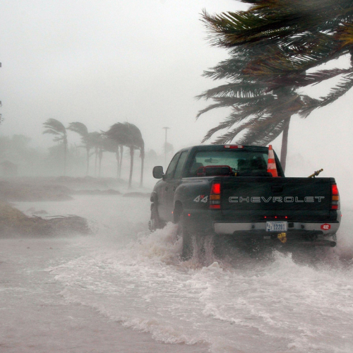
This season also went the entire month without a named storm in August, a rare occurrence that has only happened twice before since the satellite era began in 1960. The season started to see a rise in activity on Sept. 1 when Danielle formed, the first named storm in the Atlantic since Colin in early July. An average hurricane season according to NOAA is one that has 14 named storms, seven hurricanes and three major hurricanes.
Hurricane Ian made landfall at approximately 2:20PM EDT Wednesday, September 28th, making it the first hurricane to hit the United States in 2022. After making landfall near North Captiva Island as a powerful Category 4 storm on Wednesday afternoon, Hurricane Ian continued to slowly move inland over Florida Wednesday night. By 9PM EDT Wednesday, Hurricane Ian had lost wind intensity, dropping the storm to a Category 2 hurricane. Ian has continued to weaken throughout the night, the National Hurricane Center has classified Ian as a Tropical Storm as of 5AM EDT. Still, destructive winds, flooding rain and the risk for tornadoes will continue to spread north across Florida. Storm surge is expected to span from the Naples area northward through Charlotte Harbor between Wednesday and Thursday.
Coastal water levels continue to subside along the west coast of Florida. There is a danger of threatening storm surge today through Friday along the coasts of northeast Florida, Georgia, and South Carolina. Tropical Storm force winds are expected to spread northward across northeastern Florida, Georgia, and the Carolina coasts through Friday. Hurricane conditions are possible through Friday along the coasts of northeastern Florida, Georgia, and South Carolina where a Hurricane Watch is in effect. Widespread, catastrophic flooding, with major to record river flooding, will continue today across portions of central Florida with considerable flooding in northern Florida, southeastern Georgia and eastern South Carolina expected today through the end of the week.
Ian unleashed catastrophic impacts across portions of Florida on Wednesday.
Due to interaction with land, Ian is now a tropical storm. The center of Ian will emerge off the coast of eastern Florida Thursday morning and track generally northward into Friday. Ian will be able to regain some strength while over the Atlantic and it is not out of the question it intensifies into a hurricane again. Ian is forecast to make the third landfall of its lifespan and its second U.S. landfall later Friday afternoon. With the current track, this landfall will occur along the southern or central South Carolina coast. Ian will still be able to unleash flooding downpours from the Southeast to the mid-Atlantic. Days of onshore winds will also lead to extensive beach erosion and coastal flooding along the Southeast coast.
We’re Nearby & Ready to Assist You
Call ServiceMaster Recovery Management Today at 844-993-0527.
SRM Helps You Recover Today and Prepare For Tomorrow.
The experts at ServiceMaster Recovery Management have responded to some of the most devastating hurricanes in our country’s history. We leverage our real-world experience to quickly assess your situation, determine the extent of the damage, and do whatever it takes to get your business back up and running.